Navigating mountainous terrain demands accurate weather insights. How can you ensure you’re getting the most dependable mountain weather forecasts? SIXT.VN is here to guide you through the essential resources and techniques for staying safe and informed on your next adventure in Vietnam or anywhere in the world. Armed with this knowledge, you’ll be well-prepared to explore Vietnam’s stunning landscapes, from Sapa’s misty peaks to the majestic Fansipan, ensuring a safe and enjoyable travel experience. You’ll discover effective strategies for mountain microclimate predictions, utilizing real-time weather updates and gaining expertise in local weather pattern analysis.
1. Why Are Mountain Weather Forecasts So Important?
Mountain weather forecasts are essential for safety and trip planning. Mountain environments are notorious for their rapidly changing and unpredictable weather conditions. Understanding how to access and interpret accurate forecasts can be the difference between a successful adventure and a dangerous situation. Accurate forecasts also contribute to responsible tourism and sustainable exploration, promoting respect for the natural environment and minimizing negative impacts.
- Safety Implications: Mountain weather can shift dramatically in a matter of hours, with conditions ranging from sunny skies to blizzard-like storms. According to the American Alpine Club, weather is a significant factor in mountaineering accidents, highlighting the critical need for reliable forecasting.
- Trip Planning: Knowing the expected weather conditions helps you pack appropriate gear, plan your route, and schedule your activities. For example, understanding temperature variations, wind speeds, and precipitation patterns allows you to select the right clothing layers, choose a safe hiking trail, and avoid potentially hazardous areas.
- Risk Management: Weather forecasts help identify potential hazards such as avalanches, landslides, and flash floods. These risks are especially pertinent in regions like the Himalayas or the Andes, where extreme weather events can occur suddenly. Awareness of these risks enables informed decision-making, allowing you to adjust plans or postpone activities when necessary.
2. What Makes Mountain Weather Forecasting Unique?
Mountain weather forecasting is unique due to the complex interplay of elevation, terrain, and local climate patterns. These factors create microclimates and localized weather phenomena that are challenging to predict.
- Elevation Effects: As elevation increases, temperature decreases, and atmospheric pressure drops. This leads to colder conditions and higher probabilities of precipitation in the form of snow or ice. According to the National Weather Service, temperature decreases approximately 3.5 degrees Fahrenheit for every 1,000 feet of elevation gain.
- Terrain Influence: Mountain ranges act as barriers to air masses, causing air to rise, cool, and condense, resulting in increased precipitation on windward slopes. Leeward slopes, on the other hand, experience drier conditions due to the rain shadow effect.
- Microclimates: Variations in aspect (direction a slope faces) and local topography create microclimates with distinct weather conditions. South-facing slopes receive more sunlight and are generally warmer and drier, while north-facing slopes are cooler and wetter.
- Localized Phenomena: Mountain regions are prone to unique weather phenomena such as valley breezes, mountain waves, and orographic lift. These localized effects require specialized forecasting techniques to accurately predict.
- Data Scarcity: Remote mountain areas often lack dense networks of weather observation stations, making it difficult to collect real-time data for accurate forecasting. Reliance on satellite data and weather models becomes crucial in these regions.
3. Where Can You Find Reliable Weather Forecasts for Mountain Areas?
Reliable weather forecasts for mountain areas can be found through a combination of government weather services, specialized weather apps, and local meteorological resources. Here’s how to leverage these resources effectively:
-
National Weather Services:
-
Pros: Accurate, detailed forecasts from expert meteorologists; vital alerts and warnings.
-
Cons: Limited graphical interfaces; not designed for remote backcountry.
-
Usage:
- Utilize websites such as the National Weather Service (NWS) in the U.S., or equivalent services in other countries, for detailed forecasts.
- Look for mountain-specific forecasts that include elevation considerations and potential hazards.
- Monitor weather alerts and warnings for immediate threats like severe storms or flash floods.
-
-
Specialized Weather Apps and Websites:
-
Pros: Visual interfaces; model data; exact remote location forecasts.
-
Cons: Requires meteorological knowledge.
-
Usage:
- Windy.com provides weather forecast parameters that are easy to understand for non-meteorologists and integrates topographic maps for adventurers.
- Meteoblue uses artificial intelligence to process data and offer accurate temperature and wind forecasts for remote mountains.
- Check mountain-specific weather websites and apps like Mountain-Forecast for tailored information.
-
-
Local Meteorological Resources:
-
Pros: Understand model biases and local nuances.
-
Cons: Lack graphical data.
-
Usage:
- Follow local weather blogs, social media accounts, and news outlets for up-to-date information.
- Consult with local guides, park rangers, and experienced mountaineers for insights into specific mountain conditions.
- Engage with local weather communities to learn about microclimates, seasonal patterns, and potential hazards.
-
-
Aviation Weather Resources:
-
Pros: Detailed weather data, including wind speeds and direction at different altitudes.
-
Cons: Specialized terminology; requires some meteorological knowledge.
-
Usage:
- Aviation weather reports and forecasts are valuable for understanding upper-level winds and potential turbulence.
- Tools like Aviation Weather Center (AWC) offer graphical forecasts of winds aloft, icing, and turbulence.
-
-
Combination Approach:
-
Pros: Factored for public safety; smoke; volcanic ash.
-
Cons: Not designed for photography.
-
Usage:
- Compare forecasts from different sources to identify potential discrepancies and uncertainties.
- Look for consensus among forecasts to increase confidence in the predicted weather conditions.
- Adjust plans based on the most conservative forecast, especially when safety is a concern.
-
 Camping at Spencer Lake and Glacier allowed us to paddle on a tranquil glacier lake amongst icebergs, keeping a safe distance of course. The low cloud cover seen is fair weather stratus and of no concern for inclement weather. I will talk more about what the clouds are telling you in the next blog. The model forecast for this location was accurate starting 5 days before we planned to go.
4. How to Interpret Mountain Weather Forecasts Effectively?
Interpreting mountain weather forecasts effectively requires understanding key parameters, recognizing forecast limitations, and adjusting predictions based on local knowledge.
-
Key Weather Parameters:
- Temperature: Understand temperature variations with elevation; prepare for sub-freezing conditions.
- Wind Speed and Direction: Assess potential for wind chill; anticipate strong gusts and turbulent conditions.
- Precipitation Type and Amount: Differentiate between rain, snow, and ice; consider potential for flooding or avalanches.
- Cloud Cover: Recognize different cloud types; evaluate potential for visibility restrictions and changes in weather conditions.
- Atmospheric Pressure: Monitor pressure trends; falling pressure indicates approaching storm.
-
Understanding Forecast Limitations:
- Model Resolution: Be aware of model limitations in complex terrain; expect localized variations in weather conditions.
- Forecast Uncertainty: Recognize that forecasts are probabilistic; consider a range of possible outcomes.
- Forecast Horizon: Understand that forecast accuracy decreases with time; prioritize short-term forecasts for critical decision-making.
-
Adjusting Predictions Based on Local Knowledge:
- Microclimates: Account for localized variations in weather conditions due to aspect, slope, and vegetation cover.
- Seasonal Patterns: Consider seasonal trends in temperature, precipitation, and wind patterns; anticipate potential extremes.
- Local Weather Phenomena: Recognize unique weather phenomena such as valley breezes and mountain waves; adjust plans accordingly.
-
Using Graphical Forecasts:
- Meteograms: Utilize meteograms to visualize detailed forecasts over time, including temperature, wind, precipitation, and cloud cover.
- Wind Maps: Analyze wind maps to understand wind patterns at different altitudes, assess potential turbulence, and anticipate changes in weather conditions.
- Cloud Cover Maps: Interpret cloud cover maps to assess potential for visibility restrictions, evaluate solar irradiance, and identify approaching weather systems.
-
Verifying Forecast Accuracy:
- Real-Time Observations: Compare forecasts with real-time observations from weather stations, webcams, and personal observations.
- Trend Analysis: Monitor weather trends over time to identify patterns and improve forecast accuracy.
- Feedback Loops: Use feedback from past experiences to refine forecast interpretation and decision-making.
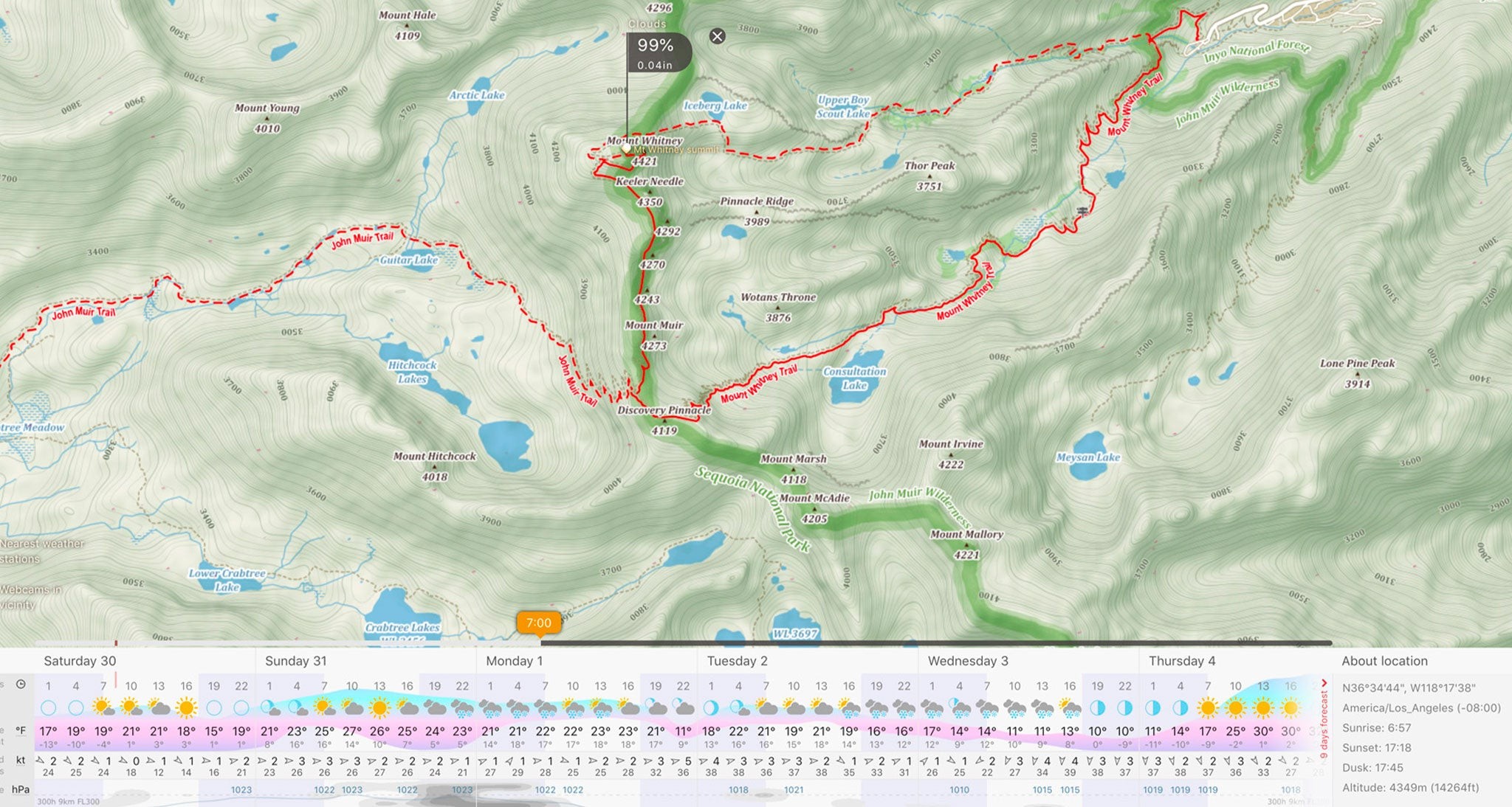 Figure 1: From windy.com I was able to zoom in to a fairly detailed topographical map which included trails, roads, and landmarks. Using the weather picker feature, I selected the summit of Mt. Whitney, the highest mountain in the CONUS. Next, I selected the
5. What Tools and Technologies Aid in Mountain Weather Forecasting?
Several tools and technologies enhance mountain weather forecasting, including weather models, remote sensing, and mobile apps. Here’s how these tools contribute to more accurate and timely forecasts:
-
Weather Models:
- Global Models: Global Forecast System (GFS) and European Centre for Medium-Range Weather Forecasting (ECMWF) provide foundational data.
- Regional Models: North American Mesoscale (NAM) offers higher resolution forecasts for specific regions.
- Ensemble Models: Meteoblue uses artificial intelligence to refine forecasts in complex terrain.
- Pros: Broad coverage, multiple updates, detailed forecasts.
- Cons: Resolution limits, complex terrain limits, potential for biases.
-
Remote Sensing:
- Weather Satellites: Geostationary and polar-orbiting satellites provide continuous monitoring of weather conditions.
- Weather Radar: Doppler radar detects precipitation intensity and movement, aiding in severe weather warnings.
- Automated Weather Stations: Surface-based stations collect real-time data on temperature, wind, pressure, and precipitation.
- Pros: Wide coverage, continuous monitoring, real-time data.
- Cons: Limited resolution, potential for biases, maintenance requirements.
-
Mobile Apps:
- Graphical Interfaces: Present weather data in an easy to understand format.
- Location-Specific Forecasts: Provide forecasts tailored to exact GPS coordinates.
- Real-Time Alerts: Offer alerts for immediate weather threats.
- Pros: User-friendly, location-specific, real-time alerts.
- Cons: Internet access required, reliance on model data, potential for inaccuracies.
-
Personal Weather Stations:
- Localized Data: Set up personal weather stations to gather data from microclimates.
- Trend Analysis: Analyze gathered data for weather patterns and improved forecasts.
- Pros: Increased accuracy, microclimate understanding.
- Cons: Requires time and meteorological knowledge.
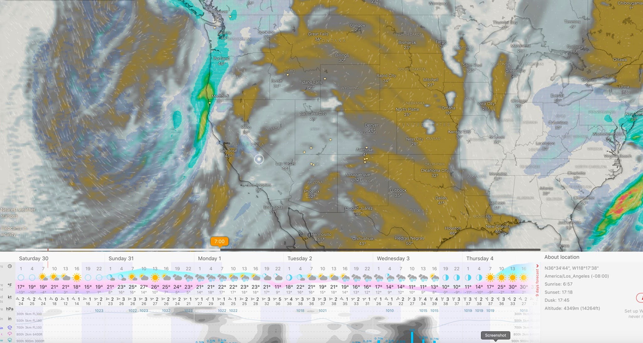 Figure 2: This is the same meteogram as seen in Figure 1, with my chosen location of Mt. Whitney shown as a white dot with white circle. This allows me to see a broader picture with a graphical forecast of clouds and 3 hour precipitation for Monday at 7AM, again from the ECMWF. The user can slide the timing bar to the right and see the change in cloud and precipitation forecasts over a larger geographical area. You can also break down the graphical cloud forecast into 3 layers, low, middle and high clouds which all mean different things. This is a very useful tool for seeing how and when major weather systems will affect my planned trip.
6. How Does Local Topography Affect Weather Patterns?
Local topography significantly influences weather patterns in mountain areas, leading to phenomena such as orographic lift, rain shadows, and valley breezes. Here’s how these topographic effects impact weather conditions:
-
Orographic Lift:
- Process: Air is forced to rise as it encounters a mountain barrier, causing it to cool, condense, and form clouds.
- Impact: Increased precipitation on windward slopes, including heavy rain or snow.
- Example: The windward slopes of the Himalayas receive significant amounts of snowfall due to orographic lift.
-
Rain Shadow Effect:
- Process: As air descends on the leeward side of a mountain range, it warms and dries, reducing precipitation.
- Impact: Drier conditions and reduced cloud cover on leeward slopes.
- Example: The Gobi Desert is in the rain shadow of the Himalayas, resulting in arid conditions.
-
Valley Breezes:
- Process: During the day, mountain slopes heat up faster than valley floors, creating upslope winds known as valley breezes. At night, slopes cool faster, resulting in downslope winds called mountain breezes.
- Impact: Daily cycle of wind direction and intensity, influencing temperature and humidity.
- Example: In the Alps, valley breezes are common during summer, creating favorable conditions for hiking and climbing.
-
Slope Aspect:
- Process: The direction a slope faces affects the amount of solar radiation it receives, influencing temperature and snowmelt.
- Impact: South-facing slopes are warmer and drier, while north-facing slopes are cooler and wetter.
- Example: In the Rocky Mountains, south-facing slopes are often snow-free earlier in the spring, while north-facing slopes retain snowpack longer.
-
Elevation Effects:
- Process: Temperature decreases with increasing elevation, affecting snow levels and vegetation zones.
- Impact: Higher elevations experience colder temperatures and a greater chance of snow, while lower elevations have milder conditions.
- Example: In the Andes, the tree line is at a lower elevation than in the Alps due to differences in latitude and climate.
-
Terrain Complexity:
- Process: Complex terrain creates localized wind patterns, including gusts, eddies, and channeled winds.
- Impact: Unpredictable wind conditions that can affect safety and visibility.
- Example: Mountain passes and canyons are prone to strong winds, requiring careful planning and awareness.
7. How to Use Weather Data for Safe Mountain Travel?
Using weather data effectively is crucial for safe mountain travel, requiring a combination of planning, observation, and decision-making. Here’s how to integrate weather information into your mountain adventures:
-
Pre-Trip Planning:
- Research Forecasts: Gather weather forecasts from multiple sources, including national weather services, specialized apps, and local resources.
- Assess Risks: Identify potential hazards based on weather forecasts, such as temperature extremes, wind, precipitation, and visibility restrictions.
- Plan Contingencies: Develop backup plans in case of adverse weather conditions, including alternative routes, emergency shelters, and evacuation strategies.
- Pack Appropriately: Pack clothing, gear, and supplies suitable for the expected weather conditions, including extra layers, waterproof outerwear, and navigation tools.
-
On-Site Observations:
- Monitor Conditions: Observe changes in weather conditions throughout the day, including cloud cover, wind direction, temperature, and precipitation.
- Identify Trends: Recognize patterns and trends in weather conditions, such as approaching storms or clearing skies.
- Assess Hazards: Evaluate potential hazards based on observed weather conditions, such as avalanche risk, ice formation, and flash flood potential.
- Communicate Findings: Share weather observations and hazard assessments with fellow travelers and local authorities.
-
Decision-Making:
- Evaluate Options: Assess the risks and benefits of different travel options based on weather forecasts and on-site observations.
- Make Informed Choices: Choose the safest and most appropriate course of action, considering factors such as experience level, group size, and available resources.
- Adjust Plans: Be prepared to modify or cancel plans if weather conditions deteriorate or pose unacceptable risks.
- Prioritize Safety: Always prioritize safety over reaching a specific destination or goal, and be willing to turn back if necessary.
-
Navigation and Orientation:
- Use Maps and Compasses: Utilize topographic maps and compasses for navigation in low-visibility conditions, such as fog or snow.
- Utilize GPS Devices: Employ GPS devices for tracking location and accessing weather information, but be aware of battery life and potential signal loss.
- Mark Routes: Mark routes and landmarks on maps or GPS devices to aid in navigation and avoid getting lost.
-
Emergency Preparedness:
- Carry Emergency Gear: Carry essential emergency gear, including a first-aid kit, signaling devices, navigation tools, and communication devices.
- Know Emergency Procedures: Understand emergency procedures for different weather-related hazards, such as avalanche rescue, hypothermia treatment, and flash flood evacuation.
- Establish Communication Protocols: Establish communication protocols with external contacts, including emergency services and family members.
8. What Are the Common Mistakes in Mountain Weather Forecasting?
Common mistakes in mountain weather forecasting include overreliance on single sources, neglecting local knowledge, and failing to account for microclimates. Avoiding these pitfalls can significantly improve forecast accuracy and safety:
- Overreliance on Single Sources:
- Mistake: Relying solely on one weather forecast or app without cross-referencing with other sources.
- Consequence: Missing crucial details or uncertainties that may be present in other forecasts.
- Solution: Consult multiple weather sources, including national weather services, specialized apps, and local resources, to get a comprehensive picture of expected conditions.
- Neglecting Local Knowledge:
- Mistake: Ignoring the expertise of local guides, park rangers, and experienced mountaineers regarding specific mountain conditions.
- Consequence: Overlooking microclimates, seasonal patterns, and potential hazards unique to the area.
- Solution: Seek advice from local experts to gain insights into the nuances of mountain weather and adjust plans accordingly.
- Failing to Account for Microclimates:
- Mistake: Assuming that weather conditions are uniform across an entire mountain range without considering variations in aspect, slope, and elevation.
- Consequence: Encountering unexpected weather conditions, such as localized snowstorms or strong winds, that are not reflected in broader forecasts.
- Solution: Pay attention to local topography and microclimates, and adjust plans based on observed conditions and potential variations.
- Ignoring Forecast Uncertainty:
- Mistake: Treating weather forecasts as definitive predictions rather than probabilistic scenarios.
- Consequence: Being unprepared for unexpected weather changes or extreme events.
- Solution: Recognize that forecasts are inherently uncertain, and consider a range of possible outcomes when making decisions.
- Misinterpreting Weather Data:
- Mistake: Misunderstanding key weather parameters, such as temperature, wind speed, precipitation, and cloud cover.
- Consequence: Making inaccurate assessments of weather conditions and potential hazards.
- Solution: Educate yourself on basic meteorology and learn how to interpret weather data from various sources.
- Not Monitoring Conditions:
- Mistake: Failing to observe changes in weather conditions throughout the day and adjust plans accordingly.
- Consequence: Being caught off guard by sudden weather changes, such as approaching storms or decreasing visibility.
- Solution: Continuously monitor weather conditions, and be prepared to modify or cancel plans if necessary.
- Lack of Preparation:
- Mistake: Entering a mountain environment unprepared for the potential weather conditions.
- Consequence: Experiencing hazardous events such as hypothermia or frostbite.
- Solution: Plan accordingly and know your limitations.
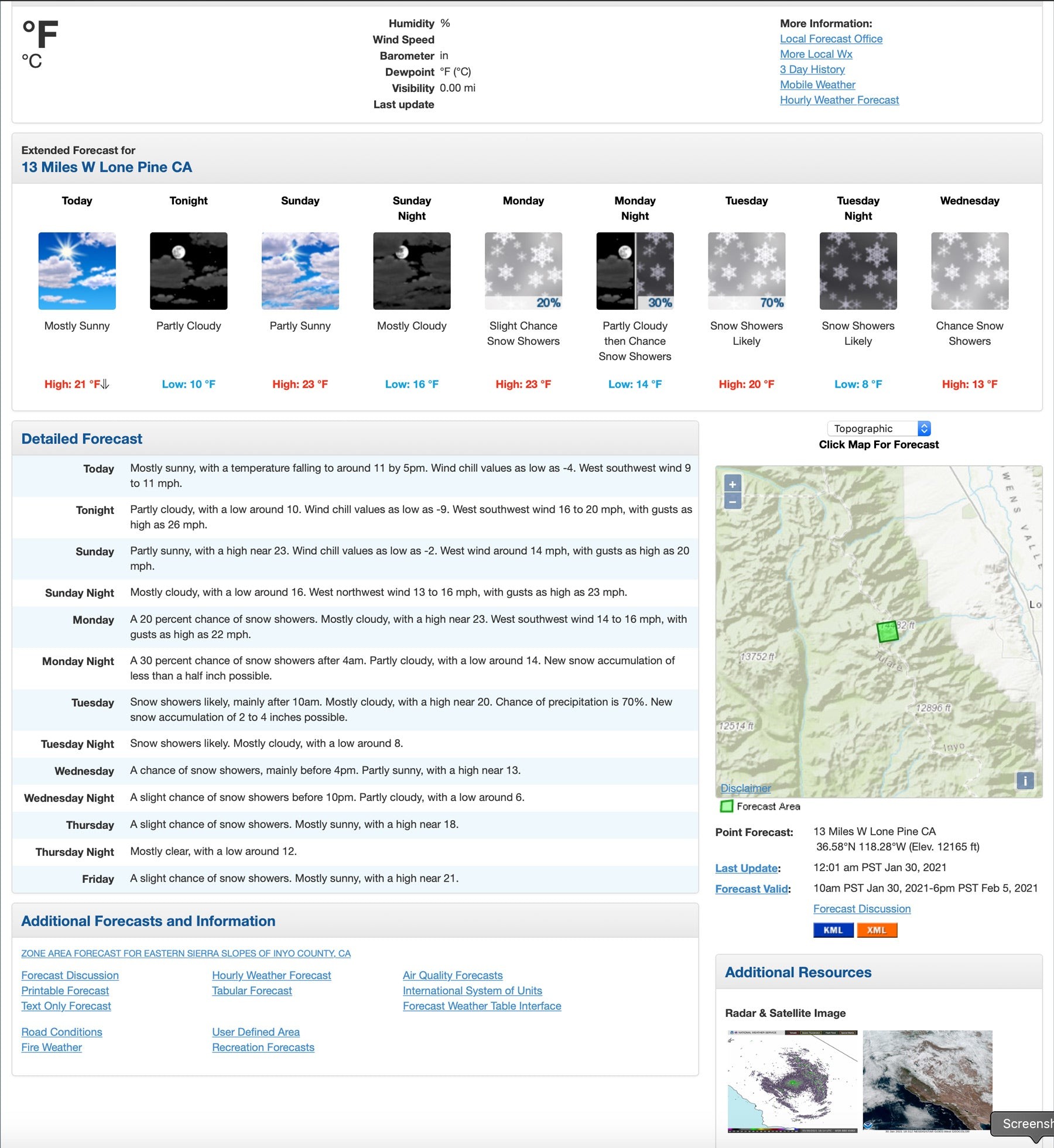 Figure 4: This is the NWS forecast for the summit of Mt. Whitney for the same time period as the ones we see from the windy.com site. The NWS sites also are tied in to street and topographic maps but the location picker isn
9. How Is Technology Improving Mountain Weather Prediction?
Technological advancements are revolutionizing mountain weather prediction through enhanced modeling, improved data collection, and sophisticated analysis techniques. These innovations are leading to more accurate and timely forecasts, enhancing safety and decision-making in mountain environments:
-
Enhanced Weather Models:
- Higher Resolution: Weather models are incorporating higher-resolution data to better capture the complex terrain and microclimates of mountain regions.
- Improved Physics: Models are refining their representation of atmospheric processes, such as orographic lift and radiative transfer, to better simulate mountain weather phenomena.
- Ensemble Forecasting: Ensemble forecasting techniques are being used to generate multiple forecast scenarios, providing a better understanding of forecast uncertainty.
-
Advanced Data Collection:
- Remote Sensing: Satellite-based sensors and radar systems are providing continuous monitoring of weather conditions in remote mountain areas.
- Automated Weather Stations: Networks of automated weather stations are collecting real-time data on temperature, wind, precipitation, and other parameters.
- Unmanned Aerial Vehicles (UAVs): Drones equipped with weather sensors are being used to gather data in areas inaccessible to traditional weather stations.
-
Sophisticated Analysis Techniques:
- Artificial Intelligence (AI): AI algorithms are being used to analyze weather data, identify patterns, and improve forecast accuracy.
- Machine Learning (ML): ML techniques are being applied to calibrate weather models, correct biases, and generate more reliable forecasts.
- Data Assimilation: Data assimilation methods are being used to integrate diverse weather data sources into weather models, improving forecast initialization and accuracy.
-
Improved Communication and Dissemination:
- Mobile Apps: Mobile apps are providing easy access to weather forecasts, alerts, and real-time observations for mountain travelers.
- Web-Based Platforms: Web-based platforms are offering interactive weather maps, graphical forecasts, and decision support tools for mountain professionals.
- Social Media: Social media channels are being used to disseminate weather information, share observations, and facilitate communication among mountain communities.
-
Case Studies:
- Swiss Alps: The Swiss Alps are using high-resolution weather models and AI algorithms to improve avalanche forecasting and enhance safety for skiers and snowboarders.
- Himalayas: The Himalayas are employing satellite-based sensors and automated weather stations to monitor weather conditions and provide early warnings of extreme events.
- Rocky Mountains: The Rocky Mountains are using UAVs and data assimilation techniques to gather weather data and improve forecasting for wildfires and water resources management.
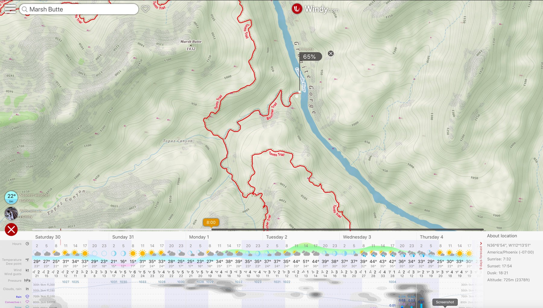 Figure 5: This is also from windy.com and shows a specific location, Boucher Rapids along the Colorado River in Grand Canyon National Park and the meteogram produced by the European Center for Medium Range Weather Forecasting, from January 30, 2021. The forecast here would be almost identical to the forecast for Phantom Ranch which is easily obtainable from the National Weather Service website: https://forecast.weather.gov/MapClick.php?lat=36.0982154447301&lon=-112.09659576416016&site=fgz&smap=1&marine=0&unit=0&lg=en#.YJ6Cki9h3OQ But what if that nearby forecast with similar elevation and orientation wasn
10. Weather Forecasting Services Offered by SIXT.VN
SIXT.VN enhances your travel experience by offering comprehensive weather forecasting services tailored to your needs in Vietnam. From providing detailed weather insights to planning your itinerary, SIXT.VN ensures you’re well-prepared for any adventure.
| Service | Description | Benefits |
|---|---|---|
| Weather-Based Itinerary | Plan your visits to destinations according to the best weather conditions. | You get to enjoy the most scenic views and have the best experiences at each destination. |
| Weather Risk Alerts | Get real-time alerts for weather risks such as storms or floods at your destinations. | Stay safe by being informed and prepared for potential hazards, ensuring a safer travel experience. |
| Personalized Forecasts | Get weather insights tailored to your travel dates and destinations in Vietnam. | More accurate planning based on weather-specific needs, optimizing your trip and ensuring that your activities are not affected by unexpected changes in weather. |
| Destination Weather Guides | Access destination-specific weather guides providing detailed information on local weather patterns, average temperatures, and seasonal variations for each location. | Plan your packing list effectively and be prepared for the unique weather conditions, ensuring a comfortable travel experience. |
| Activity-Based Forecasts | Plan your activities according to detailed forecasts relevant to each location. | Maximized enjoyment of all activities and optimal travel experiences by taking into account the best weather windows, whether it’s hiking, swimming, or sightseeing. |
Navigating weather challenges in Vietnam has never been easier with SIXT.VN. Whether you’re planning a visit to Hanoi or exploring other parts of Vietnam, SIXT.VN ensures a seamless and enjoyable journey. Stay updated with accurate forecasts and make informed decisions to enhance your travel experience.
Contact SIXT.VN for Enhanced Travel Planning
- Address: 260 Cau Giay, Hanoi, Vietnam
- Hotline/Whatsapp: +84 986 244 358
- Website: SIXT.VN
FAQ: Mountain Weather Forecasts
- Why is mountain weather so unpredictable?
Mountain weather is unpredictable due to elevation changes, complex terrain, and microclimates that cause rapid shifts in conditions. - What is orographic lift, and how does it affect mountain weather?
Orographic lift occurs when air is forced to rise over mountains, leading to cooling, condensation, and increased precipitation on windward slopes. - How do rain shadows form in mountain regions?
Rain shadows form on the leeward side of mountains as air descends, warms, and dries, resulting in reduced precipitation. - What are valley breezes, and how do they influence daily weather patterns?
Valley breezes are upslope winds that occur during the day as mountain slopes heat up, and downslope winds (mountain breezes) occur at night as slopes cool. - How does slope aspect affect temperature and snowmelt in mountain areas?
South-facing slopes receive more sunlight and are warmer and drier, while north-facing slopes are cooler and wetter, affecting snowmelt rates. - What are some common sources for mountain weather forecasts?
Common sources include national weather services, specialized weather apps like Windy.com and Meteoblue, and local meteorological resources. - What weather parameters should I pay attention to in mountain forecasts?
Key parameters include temperature, wind speed and direction, precipitation type and amount, cloud cover, and atmospheric pressure. - How can I verify the accuracy of mountain weather forecasts?
Verify accuracy by comparing forecasts with real-time observations from weather stations, webcams, and personal observations. - What are some common mistakes in mountain weather forecasting?
Common mistakes include overreliance on single sources, neglecting local knowledge, and failing to account for microclimates. - How is technology improving mountain weather prediction?
Technology is enhancing prediction through higher-resolution weather models, remote sensing, AI algorithms, and improved data collection methods.
With these insights, you’re now better equipped to navigate the complexities of mountain weather forecasting. Whether you’re planning a trek in Sapa or exploring the heights of Fansipan, reliable weather insights are key to a safe and unforgettable adventure. Contact SIXT.VN today to start planning your journey with confidence.


